
Alcatraz · San Francisco · Independent guide
Alcatraz audio guide,
five stops, free.
Press play on the Embarcadero and hear how a 22-acre island 1.25 miles offshore became a fort, a prison and a protest, then point Chiaro at whatever the five stops leave out.
Made by Chiaro. Not affiliated with Alcatraz.
Pier 33, and the island across the water
Alcatraz, San Francisco
The five stops · 11 minutes of audio
Five places, one walk,
in the order you will walk them.
Our Alcatraz audio guide starts on the mainland. Stop one is written for the Embarcadero pavement outside Pier 33 Alcatraz Landing, looking north across the bay, and it runs on into the crossing on the ferry's outside deck. Stop two is Building 64, straight ahead as you step off at the dock, and it also covers the 1857 Sally Port you walk through on the road up. Stop three is Broadway, the central corridor of the cellhouse at the top of the island; stop four is the Recreation Yard, down the steps from the cellhouse's west end; and stop five waits outside the main entrance, by the lighthouse and the Warden's House, where the road leads back down. It is self-guided and adds up to about eleven minutes of listening. The climb from the dock to the cellhouse is a quarter of a mile and 130 feet, which the park says most people walk in 10 to 15 minutes.
The practical details below were read on 27 September 2026 on the National Park Service's own Alcatraz pages and on the site of Alcatraz City Cruises, the ferry company under contract to the park, and every one is filed next to the sentence it came from, so a change on either site flags itself. Ferry times shift with the season; the concession's schedule has the day you want. On the island, the orientation at the dock and the posted closures come first, and where they and this page part ways, follow them and tell us what changed.
Bernard Spragg. NZ from Christchurch, New Zealand, CC0, via Wikimedia Commons. Photo: Bernard Spragg. NZ from Christchurch, New Zealand
.jpg)
Stop 1 of 5 · The Embarcadero, on the pavement outside Pier 33 Alcatraz Landing near Bay Street, looking north across the bay; then the outside deck of the ferry
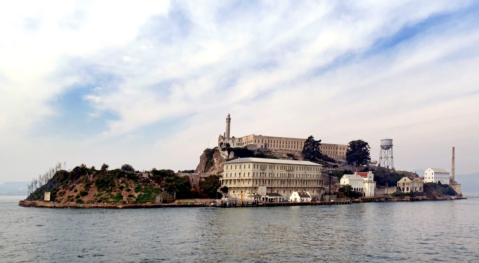
Pier 33, and the island across the water
Fortified by the US Army Corps of Engineers under Zealous B. Tower from 1853; prison buildings by the Army to 1933 and by the Federal Bureau of Prisons from 1934 · Fort completed 1859; military prison from 1861; federal penitentiary 1934–1963 · Sandstone island of 22 acres, 1,675 by 590 feet (511 by 180 m) at mean tide and 135 feet (41 m) at its highest point, 1.25 miles offshore
Look for
- The long pale block along the island's crest: that is the cellhouse, the reason most people make this crossing.
- The white tower at the southern end, the end nearest the city, which is the lighthouse, and the water tower on steel legs over on the island's northwestern side.
- The big hill rising behind the island. It is Angel Island, where the Army quarried sandstone for the fort.
Transcript (2:05)
Look north across the water, past the ends of the piers, and find the low rock with a long pale building along its top. That is the whole of it. Twenty-two acres, one thousand six hundred and seventy-five feet from end to end, about a mile and a quarter offshore.
The long block on the crest is the cellhouse. The white tower at the southern end, the end nearest the city, is the lighthouse, and the water tower on its steel legs stands over on the island's northwestern side. Behind all of it rises the big hill of Angel Island, where the Army quarried sandstone for the fort.
Because a fort is what this was first. When gold was found in 1848, San Francisco went from three hundred people to thirty thousand in a few years, and the bay became a prize worth defending. Army engineers planned a triangle of forts to guard it. One corner, at Lime Point, was never built, because the government and the landowner could not agree on a price. Alcatraz was finished first, and it became the most powerful defence on the Pacific Coast. An engineers' report of 1852 put the logic plainly: any ship heading for the city had to pass within a mile of this rock. Eleven cannons went up in 1854. By the early 1860s there were a hundred and eleven.
They never fired at an enemy. The nearest they came was in October 1863, when an unidentified warship, her flag hanging limp in the still air, was towed into the bay by men in rowing boats and turned towards Angel Island. The captain on Alcatraz fired a blank, then an empty shell across her bow. She answered with a twenty-one-gun salute. She was the Sutlej, flagship of the British Navy in the Pacific, and Alcatraz saluted back.
The name is older than any of it. In 1775 the Spanish explorer Juan Manuel de Ayala charted the bay and named an island Isla de los Alcatraces, usually translated as the island of the pelicans, though the old word may have meant gannets. Ayala actually gave the name to what is now Yerba Buena Island. An English naval officer, Frederick Beechey, later attached it to this rock, and it stuck.
What turned the fort into a prison is the water between you and it: fifty-three degrees Fahrenheit, and fast. By 1861 the island was the military prison for the whole Department of the Pacific. As the boat comes in, keep your eyes on the big building right on the waterfront. That is where you land.
Emily Mathews from Ann Arbor, MI, CC BY 2.0, via Wikimedia Commons. Photo: Emily Mathews from Ann Arbor, MI
.jpg)
Stop 2 of 5 · The dock, on the island's south-east side, straight ahead as you step off the ferry; the road up to the cellhouse starts at its north end and passes through the Guardhouse and Sally Port
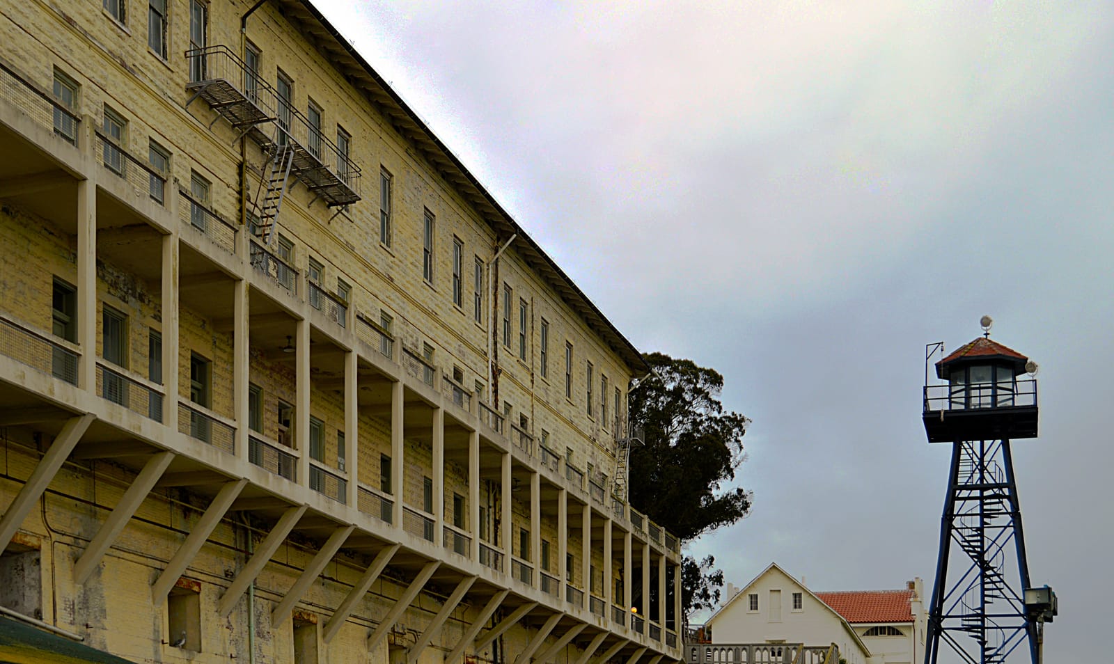
Building 64, above the dock
US Army: brick gun casemates of 1865–1867; the barracks above them built from 1905 by army prisoners under skilled civilian supervision · Casemates 1865–1867; barracks begun February 1905 · Red brick casemates under walls of hollow concrete block made on the island; about 262 by 88 feet, four storeys
Look for
- The dock level against the floors above it: brick gun rooms of the 1860s at the bottom, 1905 concrete block on top. Two buildings, forty years apart, stacked on one site.
- The penitentiary sign on the front, with the red words painted around it in 1970 by the Occupation.
- On the walk up, the arched Sally Port and the Army's sign over it, reading Alcatrace Island, 1857.
Transcript (2:03)
Stand on the dock and look up at the long building in front of you, the one with concrete galleries hanging off its face on angled brackets. Now drop your eyes to the bottom of it, at dock level. That lowest storey is a different building, and it was built for war.
Between 1865 and 1867 the Army built a row of brick gun rooms here, called casemates, with vaulted brick ceilings and walls thick enough to take a bombardment. The plan was grand: twenty-two cannon trained on the dock, five hundred men living above, four months of food stored below. The money ran out and the design went out of date before it was done. Only one tier was built, and the cannon were never mounted. What you are looking at is a fortress begun as the Civil War ended, that never got its guns.
In 1905 the Army put a barracks on top of it, and the surprise is who built it. Prisoners made the hollow concrete blocks here on the island and laid them too, with a few skilled civilian supervisors, which is how a barracks for four companies came in at forty-one thousand, three hundred and eighty-nine dollars. It held two hundred and sixty men. The whole building runs to about two hundred and sixty-two feet, and when the federal prison arrived, it filled with families: apartments for the guards, from single rooms for the bachelors to an eleven-room flat over the bay that the residents nicknamed the Cow Palace. Their children went to school on the island.
Find the penitentiary sign on the front, and the red paint around it. In 1970, during the Occupation by Indians of All Tribes, someone lettered Indians welcome and Indian land around the government's words. The occupiers also painted one apartment facing the dock a brilliant red, and nobody is quite sure why.
When you set off up the road, the first building you pass through is older still. The Guardhouse went up in 1857 with a sally port, a fortified gateway: a dry moat, a drawbridge, heavy iron-studded doors across the road, and howitzers in the side rooms pointing down towards the dock you are standing on. The prison started there, too. When the first garrison arrived in December 1859, eleven of its own soldiers were locked in the Sally Port basement.
For most of the twentieth century a wooden boathouse, added in 1920, hid the old front. When the park took it away, the Army's original sign came back into view over the arch. Look up as you walk under it. It says Alcatrace Island, 1857.
Missvain, CC0, via Wikimedia Commons. Photo: Missvain

Stop 3 of 5 · Cellhouse, at the top of the island: Broadway, the central corridor between B-Block and C-Block, running towards the clock at Times Square and the dining hall
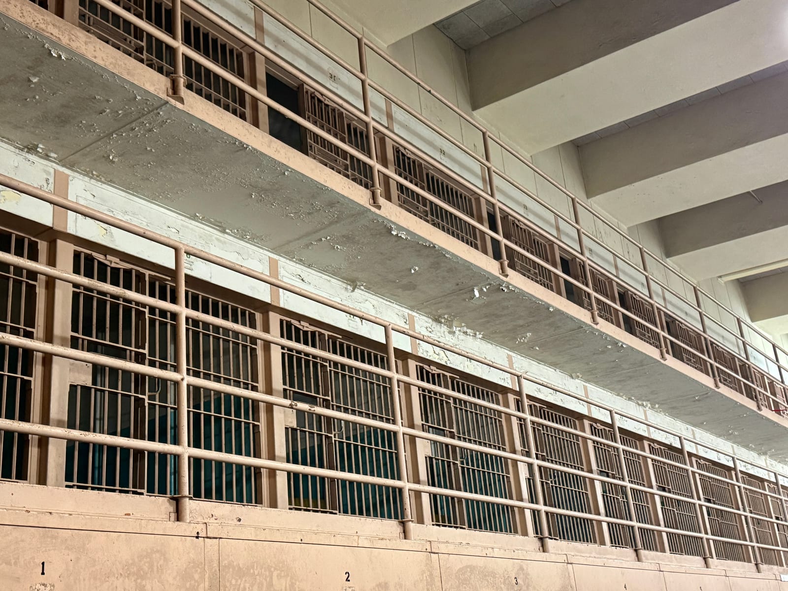
Broadway, inside the cellhouse
Army prisoners under Major Reuben B. Turner, construction engineer, for the US Army; cell fronts refitted for the Bureau of Prisons in 1934 · 1908–1912; modernized 1933–1934 · Reinforced concrete, the building 500 feet (150 m) long; 600 cells as built, typically 9 by 5 feet and 7 feet high
Look for
- The cells stacked three tiers high on either side, the upper two behind walkway railings.
- The clock at the far end of the corridor. The inmates called the space under it Times Square, and the dining hall lay beyond it; that wing is closed to visitors for preservation work until about 2028, but the clock is in view from Broadway.
- The width of a single cell front, the numbers painted along the tier edges, and how little there is between one cell and the next.
Transcript (2:50)
Stand in the middle of the corridor and look straight down it. Cells on both sides, stacked three tiers high, the upper two behind railings, the roof far above. The men who lived here named this corridor Broadway. The one along A-Block was Michigan Avenue, the one in D-Block was Sunset Strip, and at the far end, where everyone massed under a clock on the way in to meals, was Times Square. Find the clock.
Broadway had the least privacy in the building, because the whole prison walked past it to eat. Most new arrivals started one tier up in B-Block, under three months of quarantine, with no visitors for at least ninety days.
Now look at a single cell front. Five feet across. Inside, nine feet deep and seven high, with a bed, a small desk, a washbasin and a toilet on the back wall. The cells were designed so that none of them touches an outside wall. For almost the whole life of the penitentiary there was no hot water in them; the taps went in during the early 1960s, shortly before it closed.
The building is older than the penitentiary by more than twenty years. The Army began it in 1908 and finished it in 1912, using its own prisoners as the workforce, under a construction engineer, Major Reuben Turner. Six hundred cells, a kitchen, a dining hall and a hospital, all in reinforced concrete, and when it was finished it was the largest reinforced concrete building in the world. It was set on top of the old fort's citadel, whose ground floor, dug into a pit behind a dry moat, became its basement. That is where the legend of the dungeons comes from. Old iron was recycled, too: staircases and a door were kept from the citadel, and old cell bars went into the walls as reinforcement. In 1934 the Bureau of Prisons cut out the Army's cell fronts and put in two hundred and sixty-nine new ones, made from four railway carloads of steel.
It did not hold everyone. In June 1962, Frank Morris and the brothers John and Clarence Anglin hid holes at the backs of their cells behind fake ventilator grilles, climbed into the utility corridor that runs behind the cells, and from there reached the roof. They left papier-mâché heads in their beds, made in their own likeness, and went into the bay on a raft they had built themselves. A fourth man, Allen West, could not get out of his cell in time. The other three were never found, and in 1979 the FBI concluded that they had most likely drowned. Across the prison's twenty-nine years, thirty-six men made fourteen attempts: twenty-three were caught, six were shot dead, two drowned, and five are listed as missing, presumed drowned.
The most violent came sixteen years before Morris. In May 1946 a group of inmates spread the bars of the west gun gallery, took its weapons, and set off three days of fighting known as the Battle of Alcatraz. Two officers, William Miller and Harold Stites, were killed, and three inmates died.
What finally closed the place was money and salt. It cost nearly ten dollars a day to keep a man here, against three at Atlanta. Every drop of fresh water came by boat, and half a century of salt spray was eating into the concrete around you. The penitentiary closed on the twenty-first of March 1963.
Alen Ištoković, CC BY 3.0, via Wikimedia Commons, cropped. Photo: Alen Ištoković

Stop 4 of 5 · Recreation Yard, on the island's west side behind the cellhouse, reached from the cellhouse by a flight of about 45 steps; it faces the Golden Gate
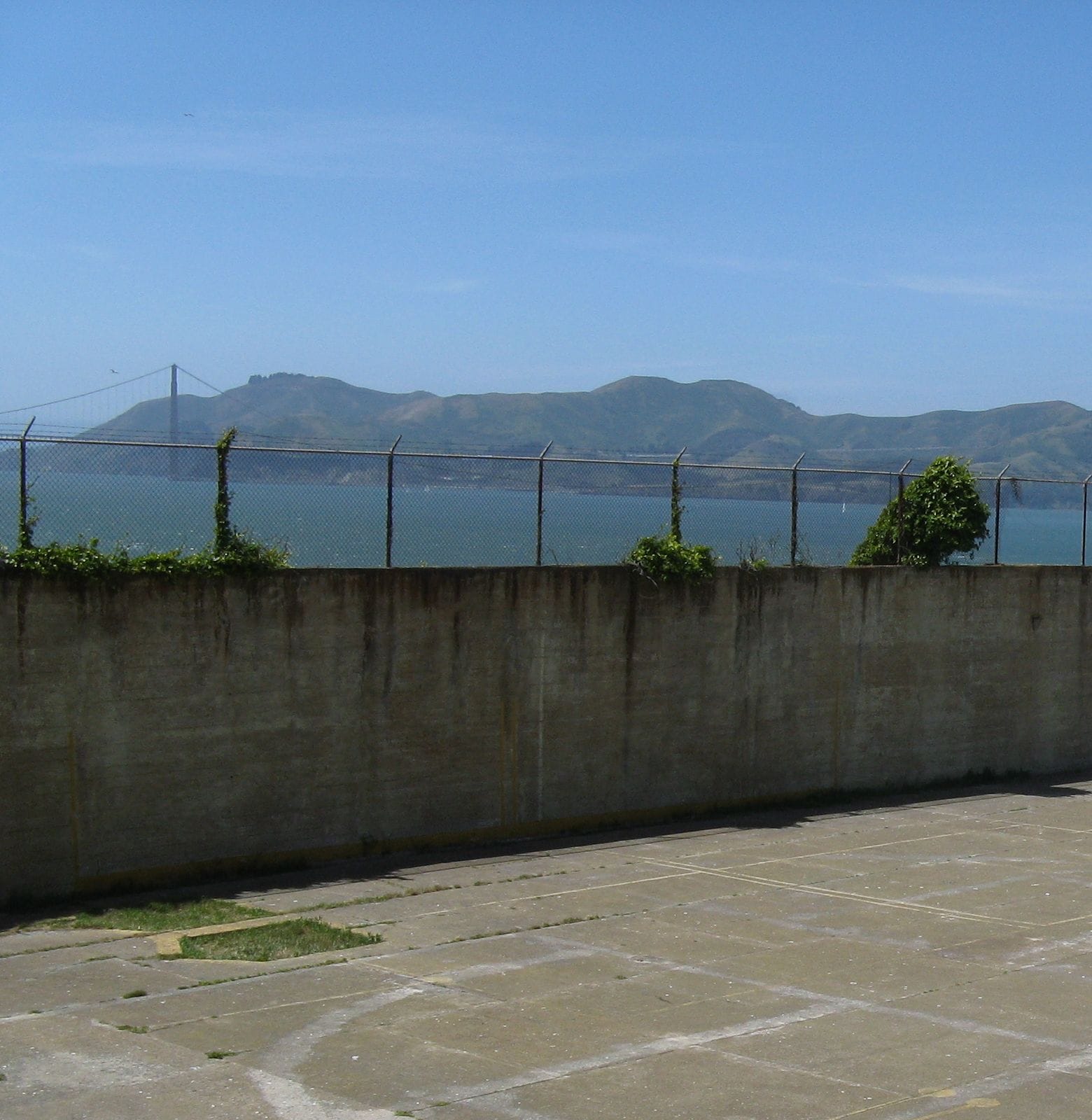
The Recreation Yard
Built with the cellhouse for the US Army, 1908–1912; paved by the Bureau of Prisons in 1936 · 1908–1912; paved 1936 · Concrete yard inside high concrete walls topped with fencing, reached from the cellhouse by about 45 stair steps
Look for
- Over the western wall, the Golden Gate strait and its bridge, with the Marin headlands to the right.
- The court lines still painted on the pavement. They suggest basketball was played here as well as baseball.
- The broad concrete flight of about 45 steps down from the cellhouse, the way you came in.
Transcript (2:09)
You came down about forty-five steps to reach this. Stop at the bottom and take in the size of it, or the lack of it. A slab of concrete, high walls, a fence along the top of the walls, and over the western wall the Golden Gate and its bridge, with the Marin headlands to the right. For the men in this yard, that strip of view was the outside world.
Until 1936 the yard was dirt. Then it was paved, and in a prison that rationed everything, time out here was rationed hardest. Inmates had it on Saturdays, Sundays and holidays, up to five hours at a time. Men who worked in the kitchen seven days a week earned short breaks here on weekdays. Men who behaved badly lost their weekends.
They played baseball and softball above all, with gloves, bats and balls but no uniforms. The yard was so small that the wall behind first base had to be padded, because runners kept overrunning the base into concrete. By 1938 there was a proper league: four amateur sides, the Bees, the Oaks, the Oilers and the Seals, named after minor-league clubs, and four league teams named after the Cardinals, Cubs, Giants and Tigers. Look down at the pavement. The painted court lines are still there, and they suggest basketball was played here too.
Mostly, though, the yard was for talking. It was the one real chance in the week for a proper conversation. Machine Gun Kelly and Basil Banghart, known as the Owl, were said to spend the whole time walking round together. It was here, too, that the warden Edwin Swope answered a man who complained to him about his hundred-and-ninety-nine-year sentence: My boy, we're all doing life. Every one of us is doing life.
The yard mattered to more than the ballplayers. The plot that became the Battle of Alcatraz in 1946 depended on getting hold of the key to this yard, to reach the tower guards and then the dock. And in 1970, during the Occupation, somewhere between four hundred and seven hundred people gathered on this pavement to demonstrate.
There is an older island under your feet. In 2019 archaeologists ran ground-penetrating radar across the former yard and found the Army's earlier fortifications in surprisingly good condition: an earthwork traverse, and beneath it a vaulted brick tunnel with its ventilation ducts, buried when the prison was built on top.
Beyond the yard wall stands the water tower, ninety-four feet tall, built in 1940 and 1941 because the island had no water of its own. Its Occupation welcome to the free Indian land was repainted when the tower was restored in 2012.
Bernard Spragg. NZ from Christchurch, New Zealand, CC0, via Wikimedia Commons. Photo: Bernard Spragg. NZ from Christchurch, New Zealand
_(37999437431).jpg)
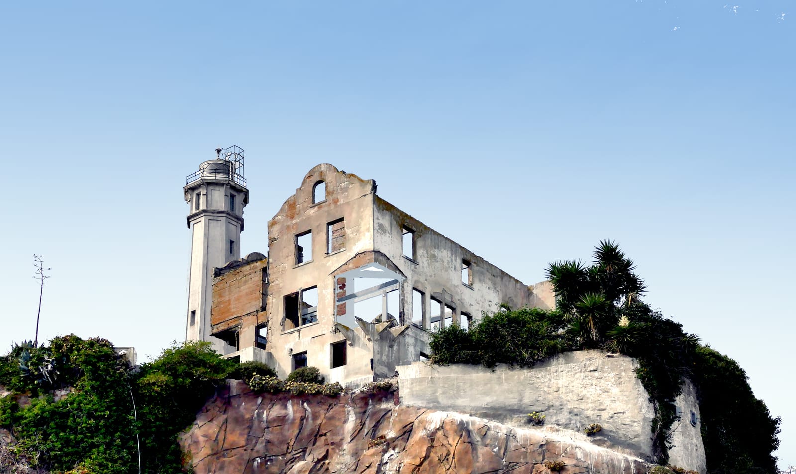
Stop 5 of 5 · Outside the cellhouse's main entrance, beside the lighthouse and the ruins of the Warden's House, looking out over the bay to San Francisco; the road back down to the dock starts here
The lighthouse and the Warden's House
Lighthouse tower built for the federal lighthouse service in 1909, replacing the light of 1854; Warden's House built for the prison in the 1920s and burned in 1970 · Tower 1909, first light 1 June 1854; Warden's House 1921 by the park's signpost, ruined 1 June 1970 · Octagonal concrete tower on a masonry base, 84 feet (26 m) tall, its light 214 feet (65 m) above the sea; the house a three-storey, fifteen-room shell
Look for
- The octagonal concrete tower of the lighthouse, and the lantern at its top.
- The Warden's House beside it: walls still standing, no roof, the tall window openings that once framed the bay.
- San Francisco across the water, a mile and a quarter off. The whole prison was built around that distance.
Transcript (2:11)
Come out of the front of the cellhouse and stop. The concrete tower beside you is the lighthouse, the roofless walls next to it were the warden's home, and straight across the water is San Francisco, a mile and a quarter off. Everything on this island was arranged around that distance.
The light was here before the prison and before the fort's guns. The first Alcatraz lighthouse was a Cape Cod-style keeper's cottage with a small tower on its roof, finished in 1853, and its lens had to sail twelve thousand miles round South America to get here. Michael Cassin lit it on the first of June 1854, and it became the first lighthouse on the Pacific Coast. The earthquake of 1906 damaged it, and the new cellhouse would have blocked it anyway, so in 1909 this octagonal concrete tower went up a little to the south, eighty-four feet tall.
Here is a trick of the ground. From the water the lighthouse looks like the tallest thing on the island, but the water tower is taller; the lighthouse just stands higher. And the keepers had help. Guards up in the watchtowers could see a bank of fog rolling in through the Golden Gate before anyone else, and they would warn the keepers so the foghorns could be started.
The house beside it had fifteen rooms over three floors, tall windows over the bay, a terraced garden and a greenhouse. The park's signpost dates it to 1921; other sources put it later in the decade. All four wardens of the penitentiary lived in it, beginning with James Johnston, a prison administrator who came out of retirement for the job and stayed fourteen years. A trusted inmate did the chores.
It burned on the first of June 1970, during the Occupation by Indians of All Tribes, and so did the lighthouse keepers' quarters and the Officers' Club. How the fires started is still disputed. The occupiers had landed in November 1969 and stayed until June 1971, claiming the island under the Treaty of Fort Laramie of 1868, and while they were here President Nixon ended the federal policy of terminating tribes and turned to self-determination instead, partly because of the attention this island drew. The National Park Service counts those nineteen months as perhaps the most influential period in the island's history.
The lighthouse was automated in 1963, the year the prison closed. On your way back down to the dock, look along the terraces for the gardens. Army families planted them, then the families of prison staff, and when volunteers cleared decades of overgrowth, they found roses still growing exactly where they had been planted more than a hundred years before.
Independent guide · Chiaro
Point Chiaro at anything at Alcatraz.
The island holds far more than five stops: gun rooms under the dock, a morgue, a power house, a guard tower on steel legs, lettering from the 1969 to 1971 Occupation on its walls. Frame any of it with your phone's camera and Chiaro will identify it, give you its builder and its worst day, and keep answering all the way back down the hill.
Before you go
Getting there
Every visit starts at Pier 33 Alcatraz Landing on The Embarcadero, near Bay Street and a little south-east of Fisherman's Wharf, San Francisco; all ferries to the island leave from there. There is no parking at the pier itself, though fifteen commercial lots lie within five blocks of it.
The Muni F Line historic streetcars run along The Embarcadero right past the pier, and Muni buses 8 Bayshore, 8BX Bayshore Express and 39 Coit stop within walking distance. The park recommends public transport over driving.
Tickets and entry
- Alcatraz City Cruises is the only ferry permitted to dock at the island, so buy from it; boats that merely circle the island do not land. There is no park entrance fee on top, and National Park passes are not accepted. The park's fee table lists the Day Tour at $47.95 from age 12 up, $45.15 at 62 and over, $29.15 between 5 and 11, and nothing for children under 5; the price covers the ferry and the cellhouse audio tour. Sales open 90 days ahead, and the park warns that the island often sells out a month or more in advance in summer and near holidays.
- Hours vary with the season. The park says departures from San Francisco begin at 8:45am, that you may return on any ferry, and that the island closes for the day at 6:30pm in summer and 4:30pm in fall, winter and spring. It is closed on Thanksgiving, Christmas Day and New Year's Day. The last boat back moves with the schedule, so check the concession's timetable for your date.
- Your ticket is needed even to join the boarding line at Pier 33. Large bags, luggage, coolers and oversized backpacks cannot come aboard or onto the island, and the pier has no left-luggage. There is no food service on the island: food is sold on the ferry, eating is allowed only on the dock, and bottled water is fine everywhere.
- From the dock to the cellhouse is about a quarter of a mile with a 130-foot climb; the SEAT electric shuttle runs from the dock to the cellhouse every half hour for anyone who cannot make it, and about 45 steps lead from the cellhouse down to the Recreation Yard. Some areas close at certain times of year for nesting seabirds, and the announcements at the dock say what is shut that day.
The official audio guide
The island's own guide is the cellhouse audio tour, Doing Time: The Alcatraz Cellhouse Tour, produced by the Golden Gate National Parks Conservancy and included in every ferry ticket; the park values it at $12. You pick up the device inside the cellhouse, and for about half an hour former inmates and correctional officers talk you through the building, in English, Spanish, French, German, Italian, Dutch, Japanese, Korean, Portuguese, Russian or Mandarin, with an English Braille transcript, an American Sign Language version on a hand-held device and an audio-described version with tactile markers. Talks by rangers and park staff are free and listed on the program board at the dock. Chiaro's five stops are independent of the park and reach past the cellhouse walls, to the crossing, the dock and Sally Port, the yard and the ruins by the lighthouse, with one stop on Broadway to hear before or after the park's tour.
Official site →Questions
Is there a free Alcatraz audio guide?
Yes. Every ferry ticket already includes the park's cellhouse audio tour, which covers the inside of the cellhouse. This page adds five self-guided stops of its own, from the Embarcadero pavement to the lighthouse, which stream straight from this web page, each with its full script set out below the player.
Can I listen to the Alcatraz audio guide without a ticket?
The first stop, yes: it is meant for the pavement outside Pier 33 Alcatraz Landing, with the island in view across the bay, and it carries on into the crossing. The other four are on the island, which you can reach only with an Alcatraz City Cruises ferry ticket, and a Day Tour ticket takes in all four, the cellhouse and the Recreation Yard included.
How much is the official Alcatraz audio guide?
It comes as part of the ticket. The park's fee table marks the audio tour as included at every age, and its own cellhouse tour page puts a $12 value on it. On that table an adult Day Tour, ferry and audio tour together, costs $47.95.
Is Alcatraz open every day?
Almost: the island closes on Thanksgiving, Christmas Day and New Year's Day, and very rarely for extreme weather. Through the rest of the year the hours change with the season, and some areas close while seabirds are nesting.
How do I get to Alcatraz?
By ferry, and only from Pier 33 Alcatraz Landing on The Embarcadero near Bay Street. Alcatraz City Cruises runs every boat that lands; sightseeing cruises that loop round the island do not put anyone ashore. The Muni F Line streetcar stops right by the pier.
Where does the Alcatraz audio guide begin?
On the mainland, on the pavement outside Pier 33 Alcatraz Landing, facing north across the water to the island. Play it there or on the ferry's outer deck; stop two picks up at Building 64, the long barracks straight ahead as you step off the boat.
More audio guides
Made by Chiaro. Not affiliated with Alcatraz.