
Stonehenge · Amesbury · Independent guide
Stonehenge audio guide,
five stops, free.
An earthwork ring about 100 metres across, dug about 3000 BC, with sarsens raised inside it about 2500 BC: five stops play right here, and Chiaro reads the rest of Salisbury Plain from a photo.
Made by Chiaro. Not affiliated with Stonehenge.
The visitor centre canopy, before the ticket booth
Stonehenge, Amesbury
That was the free part
Chiaro narrates anything at Stonehenge from a photo.
The five stops · 11 minutes of audio
Five places, one walk,
in the order you will walk them.
Stonehenge's free, self-guided audio guide starts under the visitor centre canopy, in front of the ticket booth and two kilometres west of the stones, so the first stop plays before you have even shown a ticket. Take the shuttle or walk out across the National Trust fields, and the other four follow the visitor path round the Stone Circle in the order of the site's own numbered markers: the Heel Stone and the Avenue on the north-east side, the outer ring of sarsens and lintels on the north and east, the back of the circle and the Great Trilithon on the south-west and west, and the concrete repairs and Aubrey Hole markers on the north-west as the path turns back towards the bus. Listening time comes to about ten minutes across the five. The bus ride takes five to ten minutes and the walk out twenty-five to forty; after that it is a single loop of the path.
Dates, measurements and names on this page come from English Heritage's own history pages and the transcripts of its audio tours, cross-read with Wikipedia before publication on 27 September 2026; each keeps a note of the sentence it rests on. Opening times and prices shift with the season and even the time of day, and english-heritage.org.uk carries the figures for your date. If a steward on the path tells you otherwise, trust the steward, and tell us, because we would rather fix a mistake than keep it.
Rachelle Haun, CC BY 2.0, via Wikimedia Commons, cropped. Photo: Rachelle Haun

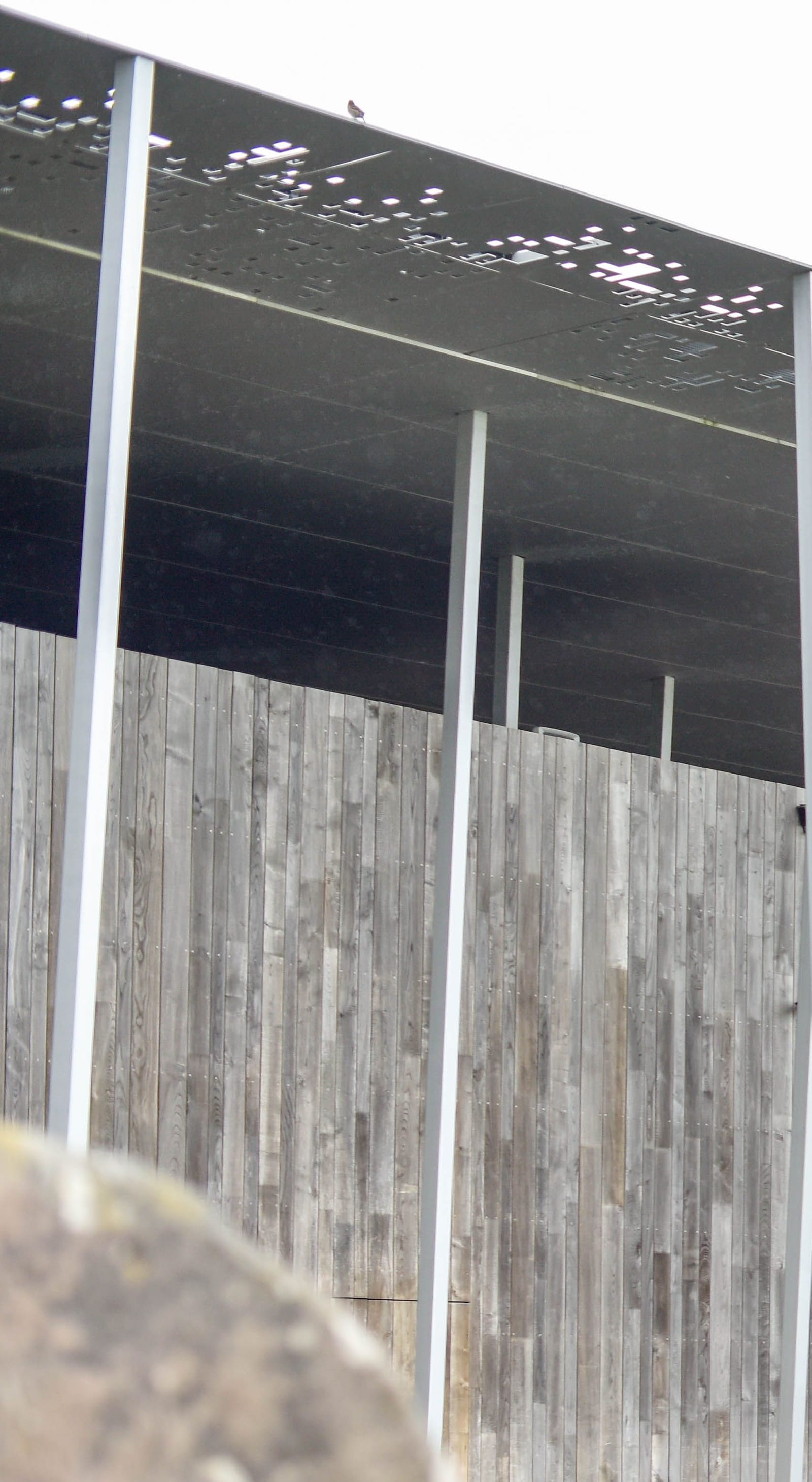
Stop 1 of 5 · Visitor Centre, the covered outdoor orientation area in the middle of the building, where the ticket booth, café, shop and exhibition doors are
The visitor centre canopy, before the ticket booth
Denton Corker Marshall, architects, for English Heritage · Opened December 2013; the A344 beside the stones closed June 2013 · Steel canopy on slender angled columns over timber-clad and glazed buildings, 2 km west of the stones
Look for
- The canopy overhead: a thin steel roof on slender columns set at angles, punched with small square openings. Nothing about the stones is visible from here, which is the point of putting the building two kilometres away.
- The ticket booth in the middle of the covered area. Everything on this side of it, including this first stop, needs no ticket.
- The way through to the back of the building, outside the shop, where the shuttle buses leave for the stones.
Transcript (1:58)
Look up before you go looking for the stones. The roof over your head is a thin sheet of steel punched with small square holes, carried on a thicket of slender grey columns set at angles, and from under it the monument is nowhere in sight. That is deliberate, and it is recent. Until 2013 the car park and the ticket office sat right beside the circle, and a main road, the A344, ran within three metres of the Heel Stone. In 1993 a committee of the House of Commons called the way Stonehenge was presented to the public a national disgrace. The cure took twenty years. The road beside the stones closed in June 2013 and was dug up and grassed over, and this building, by the architects Denton Corker Marshall, opened that December, two kilometres to the west.
The old car park had already given up something older than Stonehenge itself. When it was being laid out in the 1960s, archaeologists found four or five huge postholes that had held pine posts about three-quarters of a metre thick. English Heritage dates them to between 8500 and 7000 BC. Hunter-gatherers were marking that spot thousands of years before anyone dug the first ditch.
The ground between here and the stones has a story too, and almost nobody on the bus knows it. You cross the site of a First World War airfield. Stonehenge Aerodrome opened in November 1917 to give bomber pilots and observers their last training before the Western Front. Its night camp, with hangars for Handley Page bombers, stood close to what is now the Fargo Plantation stop, and its main camp was only about 300 metres west of the circle. You may be told that the Royal Air Force asked for the stones to be pulled down as a hazard to low flying. That story first appeared in print in 1956, and when Martyn Barber of Historic England went through the files, he found nothing to support it.
What removed the airfield was a public appeal. In 1927 a fund, with King George the Fifth as its lead subscriber, bought the aerodrome and the farmland around it, the land went to the National Trust, and by the early 1930s every building had been taken down. The open grass you are about to see was paid for by people who wanted the stones to stand alone.
Andy Li, CC0, via Wikimedia Commons. Photo: Andy Li

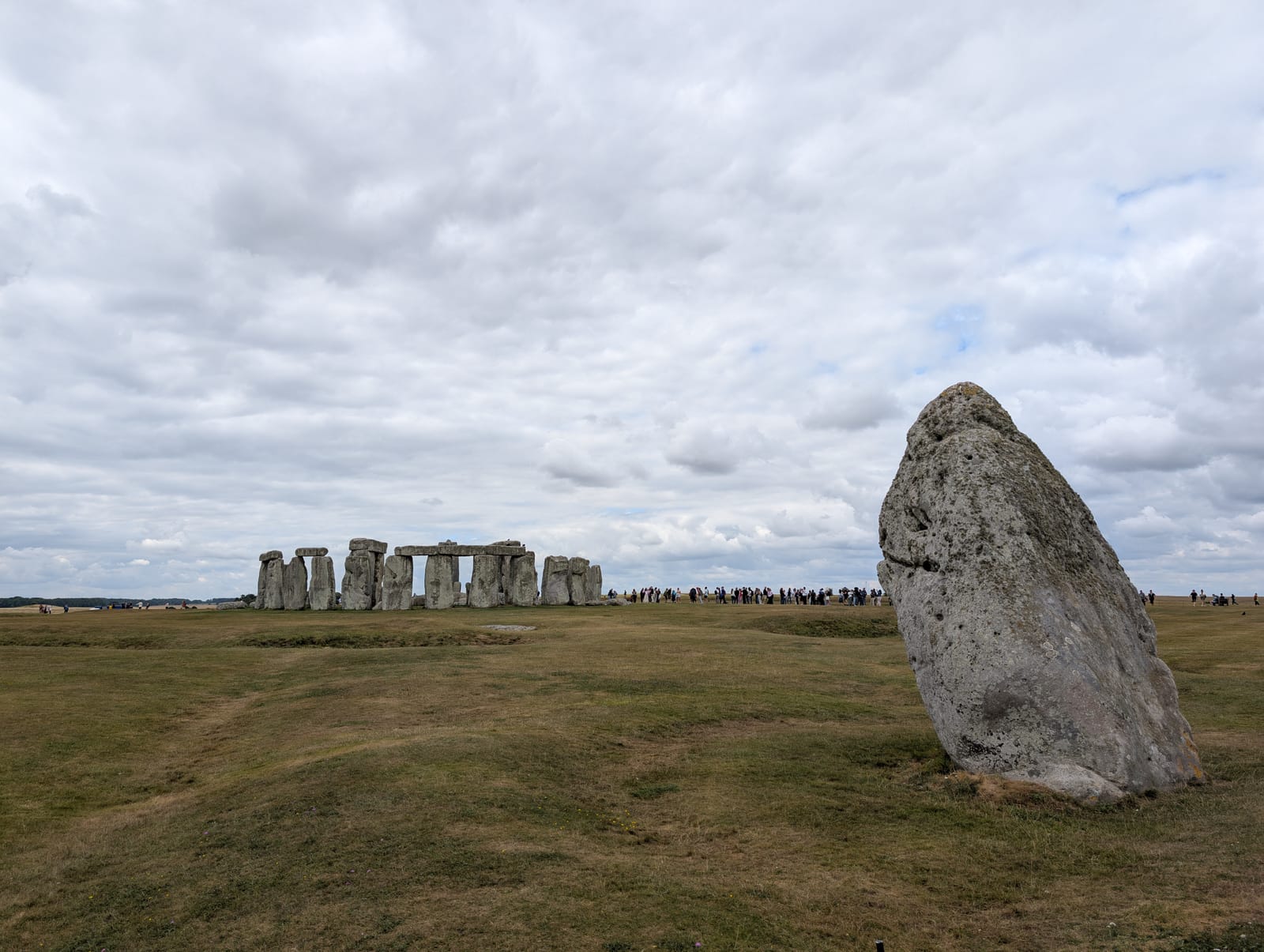
Stop 2 of 5 · Stone Circle field, north-east side, beside the visitor path, at the site's own tour marker 3, The Heel Stone and the Avenue
The Heel Stone and the end of the Avenue
Late Neolithic builders; the Avenue added in the early Bronze Age · Heel Stone set up in Stonehenge phase 3, not closely dated; the Avenue about 2300 BC · Unworked sarsen about 4.7 metres high, with a further 1.2 metres buried, standing 77.4 metres from the centre of the circle; the Avenue is a corridor about 20 metres wide
Look for
- The lean. The Heel Stone tips in towards the circle, nearly twenty-seven degrees off the vertical, and unlike every stone in the ring it was never shaped.
- Two low parallel banks either side of it, about twenty metres apart, if the grass has been cut: the last stretch of the Avenue, running down towards the River Avon.
- The bronze arrow set into the ground, marking the line of the midsummer sunrise and the midwinter sunset.
- The Slaughter Stone lying flat in the grass towards the circle. After rain, the water in its hollows can look red from the iron in the stone.
Transcript (2:00)
The big stone leaning beside the path, out on its own, is the Heel Stone, and it is the one stone here that nobody shaped. Every sarsen in the circle was dressed smooth with hammerstones. This one is a boulder left in its natural state, and it may have been lying on this very spot before people stood it up. It rises about four point seven metres to its tip, with another one point two metres below ground, and it leans in towards the circle, nearly twenty-seven degrees off the vertical. English Heritage reckons it at about 30 tons.
Now look at the grass on either side of it. If it has been cut, you can make out two low parallel banks, about twenty metres apart, running down the slope away from the stones. That is the last stretch of the Avenue, an earthwork nearly three kilometres long linking Stonehenge to the River Avon, built around 2300 BC. It follows the solstice line. From inside the circle on Midsummer's Day the sun rises over this stone, and on Midwinter's Day it sets in the opposite direction, where it would once have been framed by the two uprights of the tallest trilithon on the far side. A bronze arrow set into the ground marks that axis, so look down for it.
The line may not be entirely human. Under the Avenue run natural ridges and gullies left by the last Ice Age, and they happen to point the same way. The archaeologist Mike Parker Pearson thinks the builders noticed them, and that this is why the monument stands here at all. Until 2013 a road ran across this spot, within three metres of the Heel Stone. When the tarmac came up in 2013, the Avenue's ditches were found surviving underneath, running right through to the circle.
Between you and the stones, the long slab lying flat in the grass is the Slaughter Stone. It once stood upright at the entrance. Nineteenth-century visitors named it, taking it for an altar of sacrifice, perhaps because rainwater in its hollows turns red from the iron in the stone. There is no evidence of any sacrifice here, and the Druids those visitors had in mind lived more than two thousand years after the monument was built. The stone did hide one offering. When William Hawley dug beside it in 1920, he found a bottle of port in its socket, left there by William Cunnington, who had excavated the same hole more than a century before.
Andy Li, CC0, via Wikimedia Commons. Photo: Andy Li

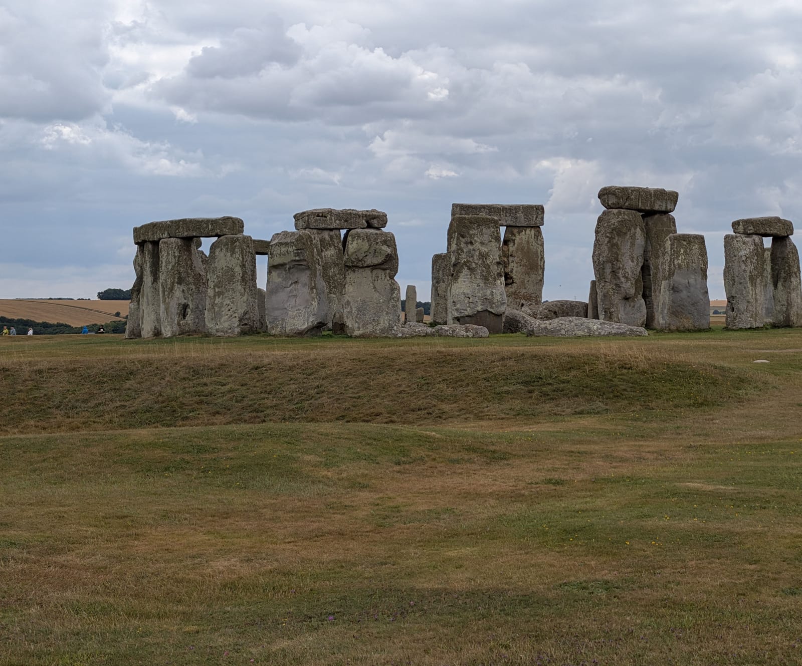
Stop 3 of 5 · Stone Circle, the visitor path on the north and east side, the site's own tour marker 4, The Stones
The outer sarsen circle and its lintels
Late Neolithic builders, working with hammerstones and antler picks before metal reached Britain · Raised about 2500 BC · Sarsen uprights and lintels in a ring about 30 metres across, the tops of the lintels 4.9 metres above the ground; the sarsens average 25 tons
Look for
- The run of lintels still sitting on their uprights. Stonehenge is the only stone circle in the world that has them.
- An upright that has lost its lintel: the bump on its top is a tenon, which once fitted a hollow cut into the underside of the lintel.
- The difference in finish. This north-east side, facing the Avenue, was dressed more finely than the side you will see at the next stop.
Transcript (2:22)
From this side of the path you are looking at the best-preserved stretch of the outer ring, and the first thing to notice is the one thing no other stone circle has. Lintels. Horizontal stones laid across the tops of the uprights, still sitting where they were put about 2500 BC. Stonehenge is the only stone circle in the world with them.
The builders treated sarsen as if it were timber. Each upright was finished with a knob on top, a tenon, and each lintel had hollows cut into its underside, mortices, that dropped over the knobs. Then the lintels were locked to each other end to end with tongue and groove joints. They are carpenter's joints, cut in stone, before there was any metal in Britain. The shaping was done by pounding the surface with hammerstones, lumps of sarsen, and the waste chips and broken hammers turn up in quantity in the field to the north, where the stones were dressed. Find an upright that has lost its lintel and you can see its tenon, a bump on the top.
Now look at the shapes. The ring is about thirty metres across, and the tops of the lintels are four point nine metres off the ground. The uprights widen slightly towards the top, so they do not seem to taper as you look up, and the lintels curve, very slightly, to follow the circle. The faces pointing inwards are smoother than the faces pointing out. A laser survey found that this north-east side, the side that faces the Avenue and the way people arrived, was the most finely finished of all. Whoever planned it knew where the audience would stand.
For a long time the source of the sarsens was given simply as the Marlborough Downs. In 2020 a team led by David Nash of the University of Brighton matched fifty of the fifty-two surviving sarsens to one area, West Woods, near Marlborough, about twenty-five kilometres to the north. The key was a core that had been drilled out of one of these stones during repairs in 1958, and that had only recently been returned.
On average a sarsen here weighs twenty-five tons. To raise one, people dug a pit with one sloping side, lined the back with wooden stakes, slid the stone to the edge and hauled it upright with ropes of plant fibre, probably over a wooden A-frame. The lintels were probably raised on timber platforms, and the tenons were trimmed last, to fit. English Heritage's estimate is hundreds of people at the stones, and more behind them growing food, minding children, making rope and cutting timber.
The ring has gaps, and not all of them are ancient. In a storm on the last day of 1900 one of the outer uprights came down with its lintel. That fall worried the owner enough to act, and it began a century of propping, straightening and concrete that you will see for yourself at the end of this walk.
Andy Li, CC0, via Wikimedia Commons. Photo: Andy Li
_2025-07-23.jpg)
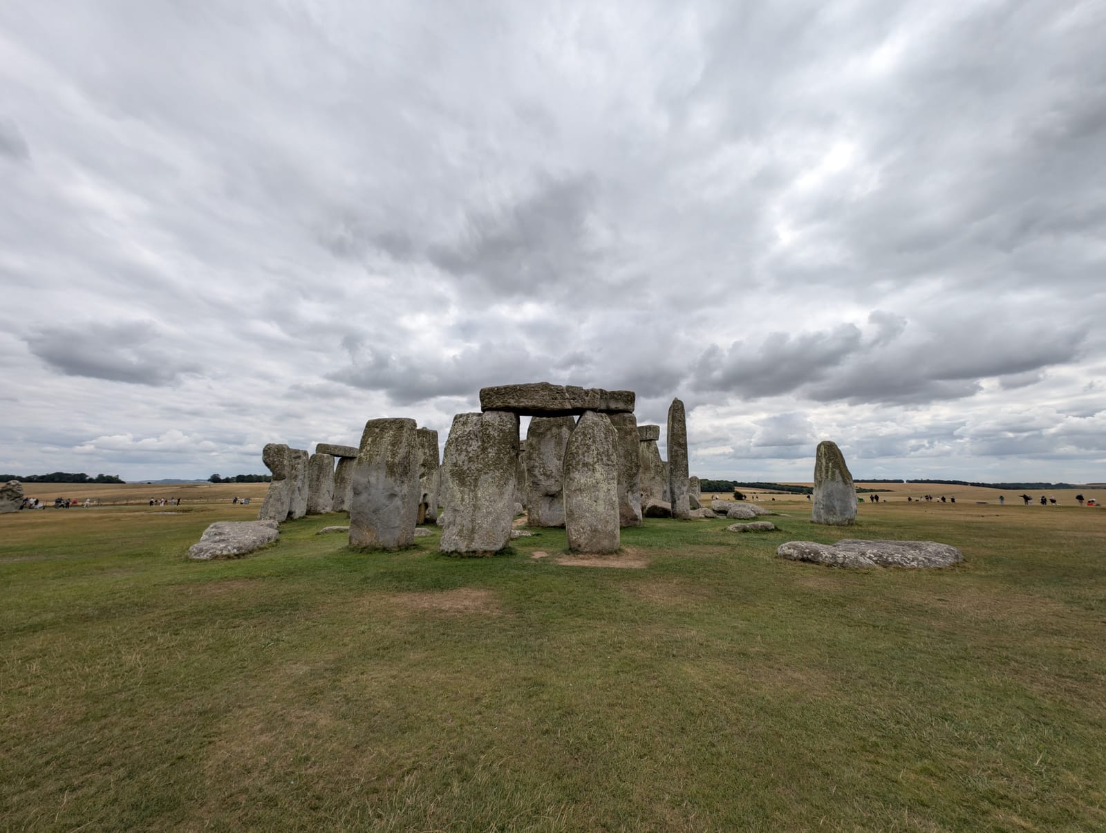
Stop 4 of 5 · Stone Circle, the visitor path on the south-west and west side, the site's own tour marker 6, The Back View
The back of the circle and the Great Trilithon
Late Neolithic builders; bluestones rearranged in the early Bronze Age · Trilithons raised about 2500 BC; bluestones rearranged about 2300 to 2200 BC · Horseshoe of five sarsen trilithons 13.7 metres across; the tallest surviving upright over seven metres high, with another two and a half metres below ground; bluestones of 2 to 5 tons
Look for
- The tallest stone, with a knob on its top: the one upright of the Great Trilithon still standing, more than seven metres above the grass.
- The gaps, and the rougher, less squared faces of the stones on this side, compared with the side facing the Avenue.
- The smaller bluestones standing between the outer ring and the horseshoe, brought from south-west Wales.
- The grass mounds on the skyline behind you: Bronze Age round barrows, built within sight of the stones.
Transcript (2:03)
You have come round to what English Heritage calls the back of the circle. There are more gaps here, and the stones that remain are rougher and less carefully squared. One is much shorter and narrower than it needed to be to carry a lintel. The English Heritage archaeologist Susan Greaney reads that as a monument built to be seen from the Avenue: this side was not the one people approached, so it got the second-best stones. Some archaeologists wonder whether the ring was ever finished. But in the dry summer of 2013, parched patches in the grass showed where missing sarsens may once have stood, and stones on this side were the first to fall; some were broken up for roadstone.
The gaps are the reason to stop, because they open the view into the middle. Inside the outer ring stood a horseshoe of five trilithons, pairs of uprights each with its own lintel, thirteen point seven metres across, with stones of up to fifty tons. The largest stood at this south-west end. Only one of its uprights is still standing, and you can pick it out: the tallest stone in the monument, more than seven metres high with another two and a half metres in the ground, and a knob on its top where the lintel sat. On Midwinter's Day the setting sun would have been framed between that stone and its partner. By 1901 it was leaning dangerously, and William Gowland straightened it and set it in concrete, moving it about half a metre from where the builders had put it.
Look past it to the centre and you may make out a long flat slab with a fallen sarsen lying across it. That is the Altar Stone, four point nine metres of purplish-green sandstone. It was long thought to be Welsh; in 2024 researchers matched it to the Orcadian Basin in north-east Scotland, some six hundred and ninety kilometres away.
Between the rings stand the smaller bluestones, two to five tons each, from the Preseli Hills in south-west Wales, more than two hundred and forty kilometres off.
Now turn your back on the stones. The grass mounds on the skyline in almost every direction are round barrows, burial mounds raised from about 2200 BC, more than three hundred of them in this landscape, many on the ridges overlooking the monument. On a clear day, look beyond the main road for a mound with a small bush growing on it. That is Bush Barrow, where two antiquaries in the early nineteenth century found a man buried with two lozenge-shaped sheets of gold, a gold belt plate and a bronze dagger decorated with gold pins.
Andy Li, CC0, via Wikimedia Commons. Photo: Andy Li

Stop 5 of 5 · Stone Circle, the visitor path on the north-west side as it returns towards the shuttle, the site's own tour markers 7, Aubrey Holes, and 8, Conservation and Restoration
The concrete repairs and the Aubrey Hole markers
Neolithic builders for the Aubrey Holes; Office of Works and Ministry of Works restorers, 1901 to 1964; English Heritage conservators, 2021 · Aubrey Holes about 3000 BC; restorations 1901, 1919–1920, 1958–1959 and 1964; lime-mortar repair September 2021 · A ring of 56 pits, each about 1 metre across, inside a bank and ditch about 100 metres in diameter; concrete foundations and infill under several sarsens
Look for
- The marker set into the path and the two in the grass either side: each shows where one of the fifty-six Aubrey Holes was dug about five thousand years ago.
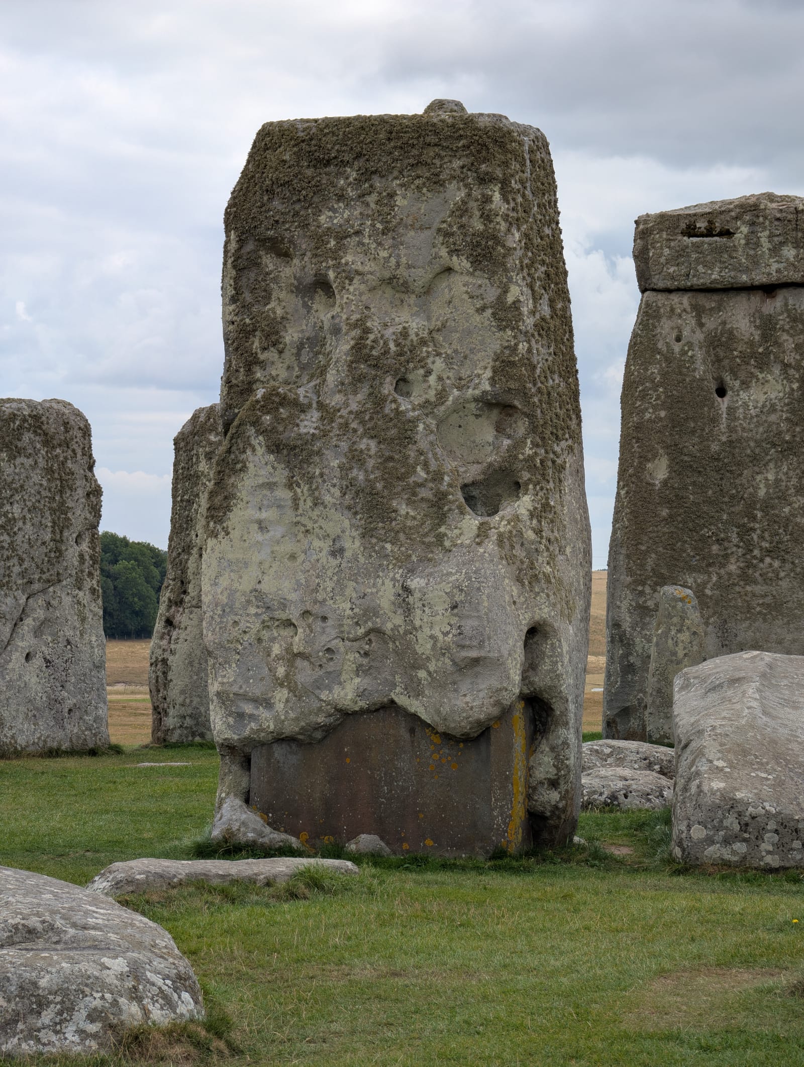
- A flat, dark block filling the hollow at the foot of one of the big inner stones: concrete from the 1958 to 1959 restoration, left visible on purpose.
- Tenons on the tops of the uprights and mortice holes under the lintels, the joints that hold the ring together.
- The lichens patterning the stones, which conservators worked around during the 2021 repair of the lintels.
Transcript (2:09)
Look at your feet before you look at the stones. Set into the path here is a small marker, and there are two more in the grass on either side of it. Each marks a hole dug about five thousand years ago, part of a ring of fifty-six pits running just inside the bank all the way round the monument, five hundred years before any of the big stones arrived. What stood in them, a timber post or a stone, is still argued over. What went into them afterwards is not. In and around these holes, and in the ditch, archaeologists have found about sixty-four cremation burials, and English Heritage thinks as many as a hundred and fifty people may once have been buried here. That makes this the largest late Neolithic cemetery in the British Isles. The holes are named after John Aubrey, who recorded them on his plan of the monument in 1666.
The dead have had an unsettled time since. William Hawley dug the cremations out in 1920, decided they were unimportant, and in 1935 reburied the lot together in a single hole, Aubrey Hole 7. In 2008 they were dug up again. More than fifty thousand fragments turned out to belong to sixty-three people, men and women in almost equal numbers, with children among them, and strontium in the bones suggests that many had lived near the bluestone quarries in Wales.
Now look at the bases of the stones nearest you. One of the big inner uprights has a flat, dark block filling the hollow at its foot. That is concrete, poured during the restoration of 1958 and 1959, and English Heritage leaves it in plain sight on purpose, because the repairs are part of the monument's history too. More concrete is hidden under the grass. Restorers straightened leaning stones from 1919 onwards, put back the trilithon that had fallen in 1797 after it had lain on the ground for 161 years, and returned in 1964 after an outer stone blew down on the morning of 10 March 1963. The most recent work was gentler. In September 2021 conservators replaced the old cement on the lintels, which traps water, with breathable lime mortar, taking care not to damage the lichens.
And the rope along the path? Visitors could walk among the stones until 1978, when vandalism and graffiti closed the circle, and in 1984 someone sprayed it with purple paint. With about a million visitors a year, English Heritage says, the ground inside would soon turn to mud. Nearly half of Stonehenge has now been excavated. The other half is still under the turf a few metres from where you are standing.
Independent guide · Chiaro
Point Chiaro at anything at Stonehenge.
Five stops, around a monument that sits among more than three hundred burial mounds, a cursus and a three-kilometre avenue. Hold your phone up to a barrow on the ridge, a stone with a knob on its top or a lintel's mortice hole, and Chiaro explains the thing in front of you and who raised it, then follows up on whatever you ask next.
Before you go
Getting there
Stonehenge, near Amesbury, Wiltshire, SP4 7DE. Everyone arrives at the visitor centre, signposted from the A303 off the A360; the car park is at the end of Loverose Way. The ticket booth stands in the middle of the covered area as you walk up to the building, which is where stop one is meant to be played, and the stones are 2 km away by shuttle or on foot.
Salisbury is the nearest railway station, 12 miles (19 km) away, with a direct line from London Waterloo that takes around an hour and a half and regular trains from Bristol, Bath and Southampton. A direct bus leaves the station forecourt hourly, or take a taxi from the station. By car it is around two hours from central London, with SP4 7DE for sat nav, and parking is charged for non-members.
Tickets and entry
- Book online by midnight the day before for the lower price, up to 15% off; you can still buy on the day, online or on arrival, at full price. Prices vary by date and by time of day, so the official prices page has the figure for yours. Booking gives you an arrival slot, and once you are in, the ticket lasts all day.
- A general admission ticket takes you all the way round the circle on the visitor path, as close as 5 metres at some points, but not inside it. Walking among the stones means a separate Stone Circle Experience booking, an hour long, in the early morning or the evening outside normal hours, and there are none in October or November. English Heritage and National Trust (England) members go free.
- Opening hours move through the year, and the site stays open later in June, July and August. Last tickets are sold well before closing, to leave time for the trip out to the stones and back, so check the official calendar for your date.
- There is no cloakroom and no shelter at the stones, and bags may be checked on arrival, so bring only what you need and dress for an exposed plain. Apart from assistance dogs, dogs cannot go into the stone circle field or on the shuttle.
The official audio guide
English Heritage's own audio guide is a free app for your phone, from the App Store or Google Play, in thirteen languages, with tours of the stone circle, the landscape and the exhibition and an audio-described tour in English. Handsets are no longer hired out on site, so download it before you go and bring headphones. This page is a shorter companion to it: five stops picked for the places you will actually stand, that run from a web page without any download, each script printed under its player for when the wind across the plain drowns the sound.
Official site →Questions
Is there a free Stonehenge audio guide?
English Heritage's own guide is free: an app for your phone in thirteen languages, covering the circle, the landscape and the exhibition, and there are no handsets on site, so bring headphones. Chiaro's five stops here are free as well and need no download; they open in the browser, starting at the visitor centre ticket booth.
Can I listen to the Stonehenge audio guide without a ticket?
The first stop, yes. It plays under the visitor centre canopy, beside the ticket booth, and describes nothing you need a ticket to see. The other four follow the visitor path round the Stone Circle, which general admission reaches, and each script is printed under its player if you would rather read them at home.
How much is the official Stonehenge audio guide?
Nothing. English Heritage's audio guide is a free download from the App Store or Google Play, in thirteen languages, and the full wording of its tours is published as PDFs on the site. Handsets are no longer hired on site, so you need your own phone and headphones.
Can I go inside the stone circle at Stonehenge?
Not on a general admission ticket. During normal hours everyone keeps to the visitor path, which goes all the way round and comes within about 5 metres of the stones at some points. Going in means booking a Stone Circle Experience, an hour in the early morning or the evening outside normal hours, with very limited places and none in October or November.
Where do I start at Stonehenge, and how do I reach the stones?
At the visitor centre, the only way in, 2 km west of the stones. Shuttle buses leave every few minutes from outside the shop and take five to ten minutes, or you can walk out through the National Trust fields in 25 to 40 minutes. Play the first stop before you set off; the Heel Stone, stop two, is near the start of the path round the circle.
More audio guides
Made by Chiaro. Not affiliated with Stonehenge.